


اخبار العرب-كندا 24: الجمعة 12 ديسمبر 2025 11:56 صباحاً
Another atmospheric river aiming for the West Coast late this weekend will provide little time to recover from this week’s flooding across portions of British Columbia.
Some communities in southern B.C. are dealing with flood warnings, evacuation orders, and evacuation alerts as waterways continue to rise throughout the region.
Residents are advised to stay alert of rapidly changing conditions and heed the advice and orders of local officials.
DON’T MISS: Busy border crossing closed due to major West Coast flooding
Next atmospheric river arrives in B.C. this weekend
We’re in a brief respite from the heavy rainfall right now, but plenty more is on the way in the coming days.

British Columbia Atmospheric Moisture Weekend
Showers will move across the South Coast through the day Friday ahead of heavier rain that’s expected to arrive late Saturday. Precipitation will grow even heavier through the day Sunday.
Advertisement
Advertisement
Advertisement
Advertisement
Forecasters are closely watching a strong plume of moisture originating near the Hawaiian Islands that will push into the West Coast on Sunday and Monday. This type of atmospheric river is commonly called a Pineapple Express.
This new arrival is forecast to be a strong AR-3 to AR-4 for the B.C. South Coast and Washington. For context, the region’s most recent atmospheric river was also rated AR-3 to AR-4.
LEARN MORE: Atmospheric rivers becoming so intense we need to rank them like hurricanes
High rainfall rates over areas already dealing with floods
Given the influence of this approaching atmospheric river, it’s likely that Sunday and Monday will bring the highest rainfall rates and totals to the region.
Advertisement
Advertisement
Advertisement
Advertisement
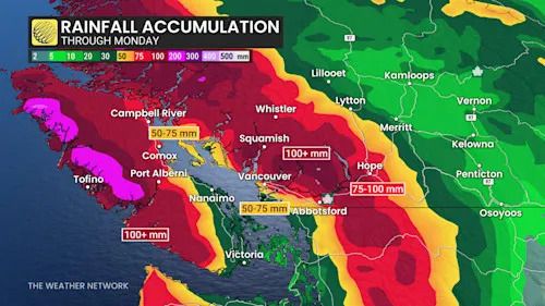
Two-day totals across the Lower Mainland will range from 80 mm on the coast to 150 mm in the Fraser Valley and the Coast Mountains.
British Columbia rainfall through Monday
Additionally, totals on the order of 80-100+ mm are possible down in Washington, whose streams and rivers run north into B.C. This could bring further flood impacts to areas already experiencing flooding issues in the Fraser Valley.
Temperatures running as much as five degrees above seasonal will contribute to melting mountain snow, adding runoff to waterways that are already swollen from the excess precipitation of late.
A significant avalanche threat will persist across higher elevations as freezing levels climb near 2000m into this weekend, which will further destabilize the region’s snowpack.
WATCH: High water levels as rain creates flooding conditions in B.C.
Click here to view the video
تم ادراج الخبر والعهده على المصدر، الرجاء الكتابة الينا لاي توضبح - برجاء اخبارنا بريديا عن خروقات لحقوق النشر للغير