


اخبار العرب-كندا 24: الجمعة 12 ديسمبر 2025 12:08 مساءً
An atmospheric river swept across southern B.C. on Wednesday, leading Abbotsford to declare a state of local emergency as hundreds of properties were put on evacuation order. The B.C. government also closed major highways between the Lower Mainland and the Interior because of flooding, falling rock and debris, and high avalanche hazards.
Here is the latest news, check back often for updates:
Friday, Dec. 12, 2025
Abbotsford schools closed Friday
All schools in the Abbotsford and Chilliwack school districts are closed to staff and students on Friday because of the flooding.
Advertisement
Advertisement
Advertisement
Advertisement
A notice on the Abbotsford school website says the decision was made to ensure the safety of students and staff.
The Chilliwack School District said the decision was made out of an abundance of caution given that Highway 1 between Exit 92 and Exit 95 is closed in both directions due to flooding.
“We recognize that many staff and families may be directly affected by road closures, evacuation alerts and orders, and difficult travel conditions. The safety of our students and staff is always our highest priority,” the school district said.
Meantime, the University of the Fraser Valley is open but all exams are postponed until next Thursday.
Advertisement
Advertisement
Advertisement
Advertisement
The university cautions that students should only travel to campus if conditions in their area are safe.
Update on highway closures
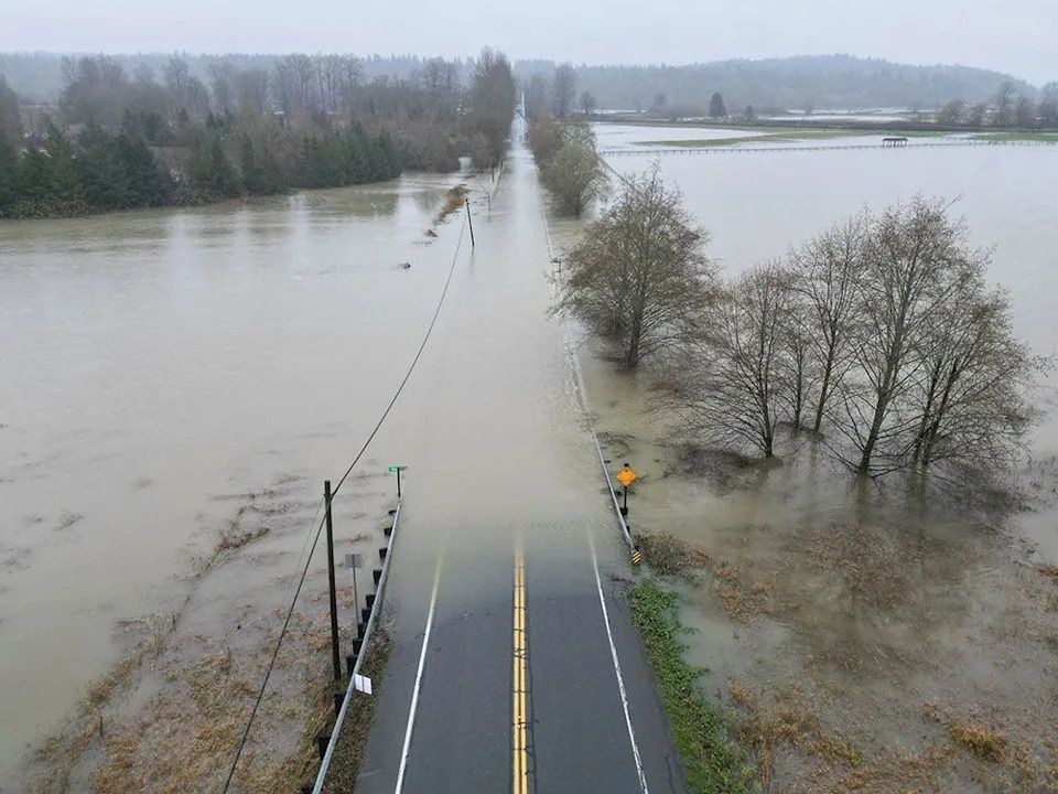
Many roads have reopened but several major highways remain closed Friday morning, including Highway 1 between Whatcom Road and Sumas Way in Abbotsford, because of flooding and landslide risk.
Here’s the latest from Drive B.C.:
• Highway 7 — reopened
• Highway 1 Canyon, from Yale to Lytton — reopened
• Highway 5 (Coquihalla) Hope to Merritt — reopened following flooding at Sowaqua.
• Highway 99 Mount Currie to Lilooett — reopened
• Highway 8 — reopened
• Highway 1 Highway 9 to Hope — closed eastbound
Advertisement
Advertisement
Advertisement
Advertisement
• Highway 1 Highway 11 to No. 3 Road — closed both directions
• Highway 3 Hope to Princeton — closed because of debris on the highway
The Sumas border remains closed to commercial traffic, with local traffic only allowed while U.S. border services is asking drivers to avoid Highway 11/Sumas because of evacuations and flooding in Washington State.
What’s happening with the weather?
While rain warnings were lifted for the Fraser Valley and Metro Vancouver, a new special weather statement is in effect Friday morning for the Fraser Valley, where flooding has reached Highway 1.
Environment and Climate Change Canada says more rainfall is in store over the next few days for the already saturated Fraser Valley.
Advertisement
Advertisement
Advertisement
Advertisement
A relatively weak frontal system is pushing into the Lower Mainland and will bring light rain today, the alert said.
The agency says the precipitation is expected to intensify Friday evening, with up to 20 millimetres of rain expected for the western and central sections of the Fraser Valley, and up to 40 mm near Hope.
Then, another wet weather system will move into the area Saturday night, according to meteorologists, followed by a potentially heavy rain early next week.
The agency says rainfall amounts are uncertain but warnings will be issued as necessary in the upcoming days.
B.C. officials to provide update on flooding at 10:30 a.m.
Several B.C. officials will hold a news conference Friday morning to update the public on the flooding situation in the Fraser Valley.
Advertisement
Advertisement
Advertisement
Advertisement
Attending will be Kelly Greene, minister of emergency management and climate readiness, Lana Popham, minister of agriculture and food, Ross Siemens, mayor of Abbotsford, and technical experts, including from the River Forecast Centre.
The media event will take place at 10:30 a.m. at the emergency operation centre, located at the Matsqui Centennial Auditorium, 32315 South Fraser Way in Abbotsford.
Check back for details from that news conference.
Abbotsford police urge residents to stay away from flood zone
Sgt. Paul Walker, a spokesperson for the Abbotsford police, posted an early-morning video to social media Friday at Whatcom Road to ask people to not to travel in the area.
Advertisement
Advertisement
Advertisement
Advertisement
“Do not come down Whatcom Road from the top of the mountain, you are not going to be able to get out to the highway or transit westbound on Old Yale Road,” he said in the video.
Walker asked drivers to use McKee Road to McMillan Road or take Marshall Road off Whatcom to get into the city westbound.
South Parallel Road between No. 3 Road and Sumas Way is also closed.
‘This is insanity’: Abbotsford residents fear flooding just four years after last disaster
As she put her five-year-old to bed, Patti Gerbrand got this question: “What if our house floats away while we’re sleeping?”
The Abbotsford mother said Thursday she was trying to keep calm for her kids while preparing to evacuate to higher ground.
Advertisement
Advertisement
Advertisement
Advertisement
“We’re ready to go, and at one point this afternoon, we’ll leave,” she said, watching as sheets of water slipped down her road and into a nearby field. She was hopeful her house would not flood because it didn’t during catastrophic storms in 2021.
The last flood was on the minds of many in Abbotsford, with weariness and anger written on the faces of those who gathered to watch the water as it surged across the border from Washington State, where the Nooksack River breached its banks Wednesday night. The water arrived in Abbotsford midday Thursday, pressing through Huntingdon village before finding lower ground on the edge of Sumas Prairie, a former lake that was drained to create farmland in the 1920s.
Read the full story here.
— Glenda Luymes
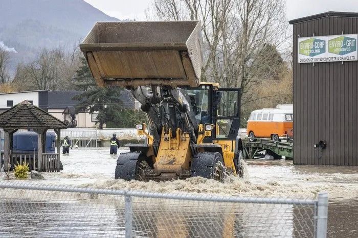
Water levels are rising at Boundary Road and Second Avenue on the Canada-U. S. border at Huntingdon on Thursday, Dec. 11, as water from recent rainfall spills into the Sumas Prairie. At least one business, Enviro Corp Recycling, was forced to evacuate.
‘Trip from hell’: Landslides, flooding shut B.C. roads as rail, U.S. border traffic also hit
A truck driver trying to haul portable camp shacks out of Vancouver found himself stranded for hours in Chilliwack on Thursday after a mudslide cut off his route along Highway 1 — one of several major corridors shut down by the B.C. government as heavy rain from an atmospheric river pummelled the Fraser Valley.
Advertisement
Advertisement
Advertisement
Advertisement
Jesse Haire left Vancouver at 3:30 a.m., headed for Whitehorse, when he came upon the closure. “I came out of Stanley Park at 3:30 a.m. and have been sitting up until I turned around at Chilliwack to Surrey,” he said, estimating the blockage added several extra hours to his trip.
Haire’s experience highlighted a chaotic night as flooding, mudslides and washouts caused the closure multiple highways linking the Lower Mainland and Interior, prompting the Ministry of Transportation to issue an advisory to avoid routes at risk of flooding, debris and high avalanche hazards.
Read the full story here.
— Sarah Grochowski
Four years after devastating B.C. floods, little has been done to protect homes, businesses, infrastructure
Atmospheric rivers are again threatening Abbotsford and other southern B.C. communities, yet there has been little progress on reducing flood risks.
Advertisement
Advertisement
Advertisement
Advertisement
Following devastating flooding in 2021, the B.C. NDP government released a 10-year flood mitigation plan in the spring of 2024, but it had no price tag, no project priorities, and no timelines.
Atmospheric rivers are again threatening Abbotsford and other southern B.C. communities, yet there has been little progress on reducing flood risks.
Following devastating flooding in 2021, the B.C. NDP government released a 10-year flood mitigation plan in the spring of 2024, but it had no price tag, no project priorities, and no timelines.
B.C. has a projected deficit this year of $11 billion.
Read the full story here.
Advertisement
Advertisement
Advertisement
Advertisement
— Gordon Hoekstra
Thursday, Dec. 11, 2025
Evacuation order issued for some properties north of Highway 1
The City of Abbotsford issued an evacuation order at 9 p.m. for several properties north of Highway 1 due to flooding. This includes the Clarion Hotel and the Ministry of Agriculture building on Angus Campbell Road.
Highway 1 closed
DriveBC is reporting as of 8 p.m. that Highway 1 is closed in both directions at Whatcom Road due to flooding. It is also closed at the intersection of Highway 11.
As of 10 p.m. water levels were continuing to rise.
People exiting Whatcom Road are to proceed Northbound on Whatcom and those exiting at Sumas Way are to proceed Northbound on Highway 11.
Highway 5 reopened in both directions
The Coquihalla Highway (5) has been reopened in both directions between Hope and Merritt as of 4 p.m.
Advertisement
Advertisement
Advertisement
Advertisement
Highway 1 remains closed eastbound between Hope and Highway 9. A detour is available via Highway 7.
‘We are not yet through this emergency,’ says minister, as evacuations expanded
An evacuation orders has been expanded in Abbotsford to 400 properties.
Kelly Greene, minister of emergency management and climate readiness, said as well 1,800 properties are under evacuation alert.
Greene provided the update at a news conference at 11 a.m. on Thursday.
“We are not yet through this emergency,” said Greene. “We are anticipating continued flow from the Nooksack today and rising water levels, and are prepared for difficult days and nights ahead.”
Geotechnical experts are on site and emergency staff are available 24/7 to provide any support required, added Greene.
Advertisement
Advertisement
Advertisement
Advertisement
“If you’re living in an area that is at risk of flooding, you should have a grab and go bag ready for everyone in your household, including pets,” she said.
There’s 66 farms registered with livestock under evacuation order, and 99 farms with livestock under evacuation alert, according to the Agriculture Ministry.
Minister Lana Popham said the flooding is affecting a mix of poultry, dairy cows and hogs, adding that at this point the animals are safe. She said she will provide updates as they come in about the farms.
Popham said she has spoken to many farmers and they are all nervously watching to see how the next 12 hours plays out.
“My message to farmers and communities is that you are not alone in this, and we need to look out for one another, and we’ll continue to monitor and support as needed,” said Popham.
A home is surrounded by floodwaters near Twin Rivers Snohomish County Park in Arlington, Wash., Thursday, Dec. 11, 2025.
B.C. River Forecast Centre continues flood warnings
David Campbell, head of the B.C. River Forecast Centre, said flood warnings are still in place for the Fraser Valley, on the Chilliwack River and for the Sumas region.
“We expect that the peak from that will come through fairly shortly as we go through the middle part of today, before we start to see that water start to decline and that water moving through,” said Campbell at the 11 a.m. news conference.
“As we go into the next 24 hours or so here, the real focus point is going to be on the Sumas region. We’ve seen the Nooksack River in the Whatcom County in Washington has been at flood stage. It breached its banks yesterday afternoon, that has led to spill overflow into the Sumas region since yesterday evening.”
Campbell said he expects the flooding won’t recede until into Friday, adding there’s only a short break in the weather before another system moves through.
“We are looking at a longer phase of potential increased flood hazard through the region, and continuing to monitor that system closely, and we’ll be providing updates as we get a better understanding of how that weekend system will come into place, as well as how much time we have to recover rivers in the next few days here before that system arrives,” he said.
Flood warnings are also now in effect for the Similkameen River tributaries, including headwater tributaries at and upstream of Princeton and the Tulameen River.
The flooding Snoqualmie River has closed NE 124th St., which connects W. Snoqualmie Valley Rd. NE on the Redmond side, and SR-203 on the Duvall and Carnation side, Wednesday, Dec. 10, 2025, near Novelty, Wash.
Some highways reopening
Janelle Staite, minister of transportation and infrastructure, said ministry staff and maintenance crews were on the ground while ministry engineers conducted an aerial assessment by helicopter to evaluate risks and identify corridor impacts.
“While there are road impacts, we are not near the state of infrastructure damage that we experienced during the 2021 event,” she said.
Staite said ground patrols of Highway 1 through the Fraser Canyon have confirmed that there was no damage, and the risk of debris coming down from the slope has subsided.
“So we’ve been able to reopen this road fully in both directions,” she said.
Geotechnical engineers have provided authorization to begin clearing the rockfall on Highway 7, between Agassiz and Hope, allowing the highway to reopen to single lane, alternating traffic.
Highway 1 eastbound in the Bridal Falls area remains closed as result of a mudslide.
Popham said engineers have assessed the site from the air and confirmed that water continues to flow from the mountain due to high streams.
“We will continue to monitor this area to determine what is safe for crews to begin clearing debris and do necessary repairs,” she said, adding an update is expected later today.
North Shore Rescue saves five people, four dogs stranded by flooding
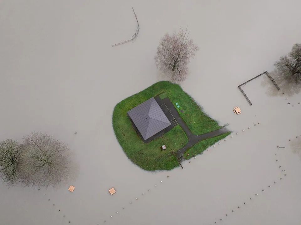
Shortly after midnight, North Shore Rescue crews used a helicopter to save a group of people and four dogs trapped on an island in the Chilliwack River, with floodwaters rising all around them.
Two NSR helicopter rescue technicians responded along with Talon Helicopters and flew to the Chilliwack River Valley, according to a social media post Thursday from North Shore Rescue.
Over the course of several hours, all people and animals were successfully rescued via hoist in challenging conditions such as wind, tight trees, and rising floodwaters, NSR said.
Crews were back in North Vancouver just after 5:30 a.m.
NSR said crews have several K9 rescue kits, which include dog harnesses specifically for helicopter rescue.
Evacuation orders in Abbotsford, alerts in Manning Park
Evacuation orders have been issued for 371 properties in Abbotsford, and a state of local emergency issued because of imminent flooding late Wednesday night.
Just after 11 p.m., the city said that residents of hundreds of properties in the Sumas Prairie West area must leave immediately due to the risk of flooding.
The orders were issued by the Fraser Valley Regional District after talks with the province and Whatcom County in the U.S., where the Nooksack River was reaching flood levels.
Floodwater is expected to arrive at the border Thursday morning, according to the city.
Firefighters and other emergency services went door to door in west Sumas Prairie in the early morning hours Thursday to hand out evacuation orders.
Farmers began to look for ways to move livestock.
As the rain stopped, residents continued to watch websites showing the Nooksack River in Washington State rising through the night. Some of that water is expected to reach Abbotsford today.
After a sleepless night for many, Sumas Prairie looked much the same early Thursday. Before dawn, Christmas lights reflected in puddles and cows were being milked. Several residents seemed to have parked their vehicles on higher ground. Many seemed to be at home despite the evacuation order.
The roads were dry apart from one area on Boundary Road. A reception centre has been set up at the Abbotsford Recreation Centre. Evacuation alerts remain in place for the eastern Sumas Prairie area.
As of 11:50 p.m., residents on the eastern edge of Manning Park were still on evacuation alert, according to an update from the Regional District of Okanagan-Similkameen.
—with files from Glenda Luymes
Related
تم ادراج الخبر والعهده على المصدر، الرجاء الكتابة الينا لاي توضبح - برجاء اخبارنا بريديا عن خروقات لحقوق النشر للغير