


اخبار العرب-كندا 24: الاثنين 29 ديسمبر 2025 03:44 مساءً
Major impacts have begun to pile up across Ontario as another powerful low-pressure system traversed through the province on Monday, bringing with it an entire assortment of hazardous conditions.
Warm air aloft provided plenty of freezing rain to southern and eastern Ontario through the day Sunday and early Monday, coating surfaces, trees, and power lines with a weighty crust of ice.
SEE ALSO: Freezing rain and ice pellets are dangerous winter hazards
Meanwhile, northeastern Ontario was forced to hunker down against blizzard conditions, which resulted in highways closures between Wawa, Sault Ste. Marie, Chapleau, and the Timmins area. The highways into and out of Wawa and Chapleau became impassable early Monday morning due to the treacherous conditions.

Northeastern Ontario Monday morning winter storm highway closures - Dec 29 2025 V2
Over 62,000 Hydro One customers were without power across the region late Monday morning as the powerful winds battered ice-covered power lines and trees.
Advertisement
Advertisement
Advertisement
Advertisement
Warmer temperatures over southern Ontario paired with the high atmospheric moisture brought heavy late-December rains to the region late Sunday. Pearson International Airport recorded 41.2 mm of rainfall on Sunday, breaking the record for all-time rainiest December day--a record that had previously stood for 63 years.
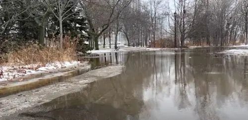
Localized flooding has also been reported in Toronto thanks to the heavy overnight rains.
Flooding in Toronto on Dec. 29, 2025 (Tyler Hamilton/TWN)
Flooding in a Toronto park on Dec. 29, 2025. (Tyler Hamilton/The Weather Network)
High winds over Lake Erie also resulted in flooding along the lakeshore, prompting the Grand River Conservation to issue a flood warning for the watershed region.
DON'T MISS: Why snow squalls are so tough to forecast
The Buffalo-Niagara International Airport also recorded a peak wind gust of 116 km/h on Monday morning.
Advertisement
Advertisement
Advertisement
Advertisement
Travel is not advised Monday; however, if it cannot be avoided, please check Ontario 511 for current road conditions before heading out, in case of any closures.
See below for social media posts showcasing the impacts of this winter storm event across southern Ontario.
Advertisement
Advertisement
Advertisement
Advertisement
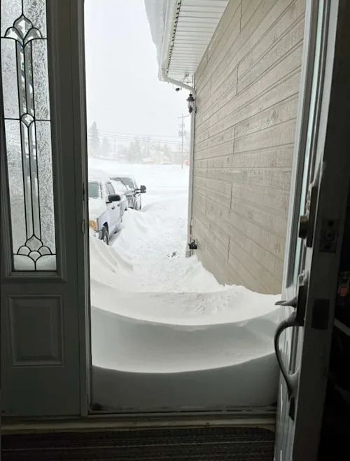
Marie Chisolm/submitted: Cochrane, Ontario snow storm. Dec. 29, 2025
Cochrane, Ontario. Dec. 29, 2025. (Submitted)
Advertisement
Advertisement
Advertisement
Advertisement
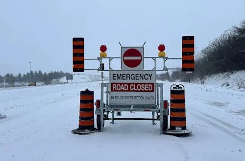
Mark Robinson: Road closed, winter storm, delays closures roads roadway travel impacts. Dec. 29, 2025
Road closures reported in New Hamburg, Ont. Dec. 29, 2025. (Mark Robinson/The Weather Network)
Advertisement
Advertisement
Advertisement
Advertisement
WATCH: Snow squalls bring hazardous conditions across Ontario’s snowbelt
Click here to view the video
WATCH: Colorado low brings slick roads and snow squalls to Ontario
Click here to view the video
تم ادراج الخبر والعهده على المصدر، الرجاء الكتابة الينا لاي توضبح - برجاء اخبارنا بريديا عن خروقات لحقوق النشر للغير