
اخبار العرب-كندا 24: الأربعاء 24 ديسمبر 2025 02:08 مساءً
Parts of the East Coast will get a guaranteed white Christmas this year with a little help from Mother Nature this week.
A low-pressure system making a cross-country trek will intensify south of Nova Scotia on Christmas Eve and track towards Newfoundland, bringing widespread, blustery winds, a heavy swath of snow and possible blizzard conditions for Christmas Day.
CHECK OUT: Scientists find unusual structure under Bermuda that causes it 'float'
Heavy snow and strong winds will continue through the day across eastern Newfoundland with possible blizzard conditions and very difficult travel. Make sure to stay updated on the latest alerts.
Advertisement
Advertisement
Advertisement
Advertisement
That won't be the end of the winter blast, either, as a second storm will follow on Boxing Day, threatening similar conditions and travel issues.
Christmas Day winter storm threatens travel in Newfoundland
Heavy snow will spread across eastern Newfoundland on early-morning Thursday, including the Avalon Peninsula. Snow rates will intensify through the morning hours, along with wind gusts.

Atlantic Canada precipitation forecast Thursday morning
Snowfall rates of 2-4+ cm an hour are forecast for the Avalon through the morning.
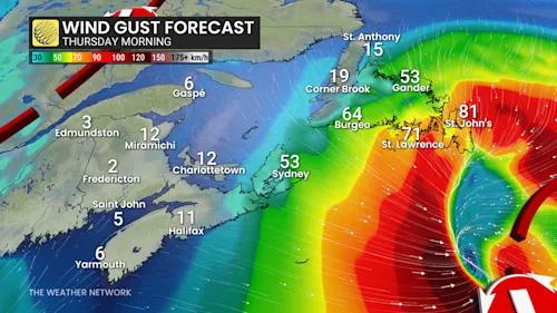
Wind gusts 70-90+ km/h are expected across the Avalon and the eastern half of the island, with the strongest gusts reserved for exposed, coastal communities.
Atlantic Canada wind gust Thursday morning
St John’s should see snow turn to rain for a few hours later in the afternoon on Thursday.
Advertisement
Advertisement
Advertisement
Advertisement
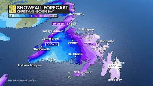
While the swath of the heaviest snow has some uncertainty in its location and amount, snowfall totals could range between 20-30+ cm.
Newfoundland snowfall Christmas Day to Boxing Day
SEE ALSO: Why snow squalls are so tough to forecast
Hazardous travel can be expected both Christmas Day due to slick roads and whiteout conditions. As well, some power outages are also possible with the strong winds.
Followup storm on Boxing Day
Another system will track hot on the heels of the first system for Boxing Day, taking a similar track and spreading another healthy swath of snow for the Avalon.
The system will need to be closely monitored. Check back as we continue to monitor the threat for a second system and round of snow.
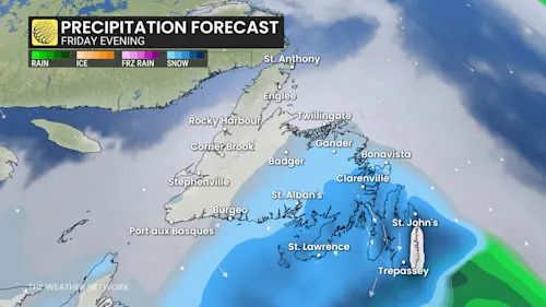
Atlantic Canada precipitation forecast Friday evening
There is a higher likelihood of this storm retrograding over the island, turning the initial blizzard conditions to rain for the eastern half of the province. If the warm air remains offshore, the snowpack from the initial storm could result in prolonged blizzard conditions for Saturday.
Advertisement
Advertisement
Advertisement
Advertisement
Similar to Christmas Day, a potential for slick roads and whiteout conditions could make for treacherous travel at times. As well, some power outages are also possible with the strong winds.
Stay tuned to The Weather Network for the latest Newfoundland forecast updates.
تم ادراج الخبر والعهده على المصدر، الرجاء الكتابة الينا لاي توضبح - برجاء اخبارنا بريديا عن خروقات لحقوق النشر للغير