


اخبار العرب-كندا 24: الثلاثاء 16 ديسمبر 2025 11:44 مساءً
A cross-country low soon will impact Canada from coast to coast, bringing wintry impacts across nearly every province.
The system has weather alerts spanning more than 4,600 km, stretching from Vancouver Island to Quebec’s North Shore.
British Columbia
The low-pressure system originated over central B.C, delivering widespread rain to the South Coast and snow to alpine regions.

B.C. additional rainfall through Wednesday
As freezing levels dropped to near 1,000 metres, Grouse and Cypress Mountains may wake up to snow Wednesday morning.
Prairies
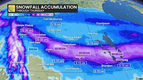
After crossing the Rockies, the system redeveloped into an Alberta clipper. It will impact the Prairies through Wednesday and into early Thursday, bringing 10-30 cm of heavy snow and winds gusting 80-100+ km/h.
Prairies snowfall outlook through Thursday
Blizzard conditions are possible from Grande Prairie, Alta., to Winnipeg, Man.
Advertisement
Advertisement
Advertisement
Advertisement
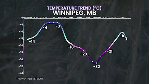
In its wake, a strong cold front will usher in frigid Arctic air across the Prairies, with some cities experiencing temperature drops of up to 30 degrees, and frigid wind chills.
Winnipeg, Man., temperature trend
Ontario
The system’s next stop is Ontario. Northern Ontario will see 20-40 cm snow from Wednesday afternoon through Friday. Meanwhile, southern Ontario will remain relatively mild as a warm front moves in, with temperatures 5-7 degrees above seasonal.
That will prompt heavy rain on Thursday as the cold front moves in.
Ontario rainfall this week
But behind this front, colder air will move in Thursday night into Friday morning. That will allow for icy conditions before colder air returns and lake-effect snow redevelops Friday.
Quebec
By Thursday, western Quebec will see 20-40 cm of heavy snow, while southern regions will experience mild temperatures and heavy rain Thursday night into Friday.
Advertisement
Advertisement
Advertisement
Advertisement
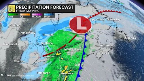
Colder air moves in Friday evening, allowing precipitation to transition to light snow on the backside of the system.
Quebec precipitation timing Friday morning
Atlantic Canada
By Friday, the clipper will reach the end of the line and makes its final stop in Atlantic Canada.
Mild conditions will persist, with primarily heavy rain expected through Saturday.
تم ادراج الخبر والعهده على المصدر، الرجاء الكتابة الينا لاي توضبح - برجاء اخبارنا بريديا عن خروقات لحقوق النشر للغير