


اخبار العرب-كندا 24: الخميس 11 ديسمبر 2025 08:44 مساءً
Expect temperatures to plummet as a reserve of exceptionally cold Arctic air begins to move south in the days ahead.
Frigid air will make its first stop on the Prairies on Friday before moving toward Ontario and Quebec into the day Sunday. The cold air may play a crucial role in developing a strong winter storm for Atlantic Canada by Monday.
DON'T MISS: What is the polar vortex? How it’s responsible for dangerous cold
Unusually cold temperatures for this point in the season
Extreme cold crossed over from Siberia to the Yukon this week, sending temperatures into rare territory for this early in the year.

Extreme Cold Summary Territories December 10 2025
Braeburn, Yukon, recorded a -53°C reading on Wednesday, which is the coldest it’s been this early in the year since Ross River, Yukon, registered that same temperature on Dec. 5, 1995. Whitehorse also experienced their earliest -40°C temperature since 2006.
Advertisement
Advertisement
Advertisement
Advertisement
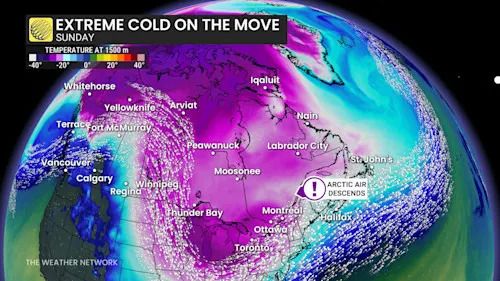
This slug of Arctic air is dislodged and on the move to round out the week, which will send temperatures plummeting throughout much of the country.
Extreme Cold Upper Air Sunday
Even though readings won’t be quite as cold as we saw across the territories, conditions will still be very cold with temperatures well below seasonal for the middle of December.
Folks across the Prairies would be wise to stay inside on Friday if possible, as widespread wind chills in the -30s and -40s will be common across all three provinces.
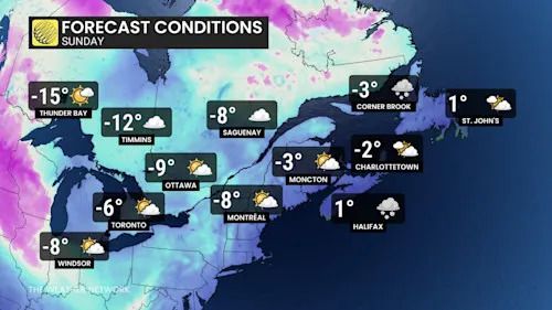
Eastern Canada Forecast Temperatures Sunday
The frosty air will move into Ontario and Quebec by Sunday, with forecast daytime high temperatures of -6°C in Toronto, -8°C in Montreal, and -9°C in Ottawa.
Advertisement
Advertisement
Advertisement
Advertisement
While the heart of the cold air will fall apart as it interacts with the warmer waters of the Great Lakes, we’ll still see below-seasonal air head toward Atlantic Canada to start the next workweek. This could even help to kick off our next winter storm for portions of the region.
WATCH: What is the polar vortex?
Click here to view the video
تم ادراج الخبر والعهده على المصدر، الرجاء الكتابة الينا لاي توضبح - برجاء اخبارنا بريديا عن خروقات لحقوق النشر للغير