


اخبار العرب-كندا 24: السبت 10 يناير 2026 09:20 مساءً
Another messy wintry mix will spread across Atlantic Canada on Sunday and linger into Monday, coating the region with the entire spectrum of icy precipitation.
Wintry mixes have been a staple of our conditions so far this season. Some communities will see several different types of precipitation in rapid succession through the beginning of the workweek.
DON’T MISS: El Niño incoming? Forecasters see signs of big changes ahead
A true wintry mix spreads over Atlantic Canada
Here’s a region-by-region breakdown of how the precipitation will unfold in your area on Sunday and into early Monday.
Advertisement
Advertisement
Advertisement
Advertisement
New Brunswick: Temperatures should allow the province to see mostly snow from this system, with a wintry mix expected near the Bay of Fundy. Most areas should see 5-10 cm of snow through Sunday evening. A few spots in eastern New Brunswick could see up to 15 cm through early Monday as the system rapidly intensifies in the Gulf.

Atlantic Canada snowfall outlook through Monday
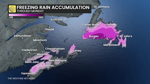
Nova Scotia: Warmer temperatures here will allow precipitation to begin as a wintry mix in central Nova Scotia before changing over to rain by the early afternoon hours. The highest risk for freezing rain includes the Annapolis Valley up toward Cape Breton.
Prince Edward Island: The island will find itself caught between milder air to the south and colder air to the northwest, which will likely promote a true wintry mix throughout the event. Expect precipitation to begin as snow that transitions to ice pellets or freezing rain, then over to rain for eastern portions of the island, before all changing back to snow early Monday.
Atlantic Canada freezing rain accumulation through Monday
Newfoundland: Periods of snow will quickly give way to a wintry mix across a large portion of the island by Sunday evening. The warm front will deliver 5-10+ mm of freezing rain to central Newfoundland before precipitation transitions back over to snow Monday afternoon. Western parts of the island can expect 10-20+ cm of snow, with just a dusting in the forecast for the Avalon.
Beware a risk for high winds into Monday
The wintry mix isn’t the only hazard that’ll accompany this system across Atlantic Canada.
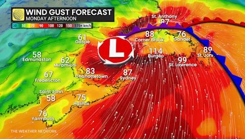
Atlantic Canada wind gusts Monday afternoon
A rapidly intensifying low-pressure system over the Gulf of St. Lawrence is a recipe for strong winds throughout the entire region.
Advertisement
Advertisement
Advertisement
Advertisement
Widespread wind gusts of 60-80+ km/h are in the forecast. P.E.I. could see gusts as high as 100 km/h, with gusts up to 120 km/h possible on Cape Breton. The southern shores of Newfoundland may see gusts as strong as 130 km/h on Monday.
WATCH: La Niña is fading, and El Niño may arrive by this summer
Click here to view the video
تم ادراج الخبر والعهده على المصدر، الرجاء الكتابة الينا لاي توضبح - برجاء اخبارنا بريديا عن خروقات لحقوق النشر للغير