
اخبار العرب-كندا 24: الثلاثاء 6 يناير 2026 08:08 صباحاً
A new and messy system moved into the province on Tuesday, bringing a risk of several hours of freezing rain, rain and a bout of snow to parts of southern Ontario.
With the risk of freezing rain, special weather statements and yellow-coded freezing rain warnings are in place for parts of the region, including the Greater Toronto Area (GTA).
DON'T MISS: January outlook: Winter hits pause in Canada before striking back
As well, some areas north of the GTA could see 5-10 cm of snowfall while southwestern areas and the Golden Horseshoe see a transition to rainfall later on Tuesday.
Advertisement
Advertisement
Advertisement
Advertisement
Stay alert for possible icy, slippery road conditions. Travel is likely to be impacted, so prepare for delays and changing road conditions. Plan ahead and keep an eye on highway conditions before hitting the road on Tuesday.
School buses in Halton, York, and Wellington-Dufferin regions were cancelled early Tuesday morning due to the icy weather.
Start of January thaw brings messy system on Tuesday
Freezing rain will continue to spread into southern Ontario through the morning hours, becoming more widespread and reaching the GTA through the late morning hours and early afternoon. Special weather statements and yellow-coded freezing rain warnings are in place across the region.
"Local utility outages are possible. There is risk of injury due to slips and falls," Environment and Climate Change Canada states in their warning.

Southern Ontario forecast freezing rain ice accumulation through Tuesday- Jan. 6, 2026
Several hours of freezing rain are in the forecast north and west of the GTA on Tuesday, which will result in 2-5 mm of ice accretion.
Advertisement
Advertisement
Advertisement
Advertisement
The freezing rain is forecast to transition into a slushy mix across the GTA in the afternoon and early evening, which may impact evening commutes.
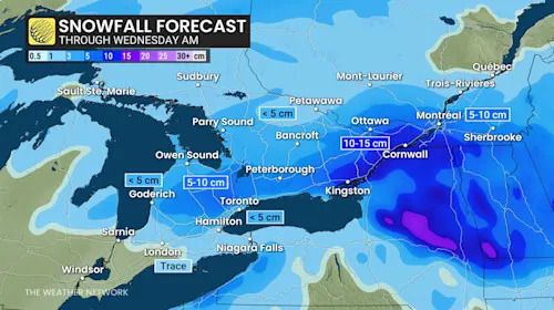
Further north, we're looking at a swath of heavy snow, amounting to 5-10 cm, along the Oak Ridges Moraine and toward Kingston.
Ontario forecast snowfall totals through Wednesday morning - Jan. 6, 2026
Meanwhile, in eastern Ontario, we could see up to 10 cm of snowfall through Tuesday, with flurries lingering into Wednesday morning. Communities southeast of Ottawa could even see up to 15 cm of snow.
Commuters on Wednesday and Thursday morning shouldn't let their guards down as the risk of fog rolls into southern Ontario thanks to an incoming mild airmass.
WATCH: After 27 snow days last winter, Ontario school board rethinks approach
Click here to view the video
Mild and wet end to the week
The active weather pattern persists with two additional systems expected to impact the region later this week.
Advertisement
Advertisement
Advertisement
Advertisement
The first system arrives Friday, bringing widespread rain as mild temperatures rise to the upper-single digits. Originating from the southern U.S., this system carries warmer conditions.
The second system on Saturday may bring a more wintry mix, including various precipitation types, stronger winds, and greater potential for impacts. Yet another round of heavy snow is forecast east of Lake Superior and Georgian Bay.
WATCH: January cold hits pause before winter stages a comeback in Canada
Click here to view the video
Stay with The Weather Network for the latest updates across Ontario.
تم ادراج الخبر والعهده على المصدر، الرجاء الكتابة الينا لاي توضبح - برجاء اخبارنا بريديا عن خروقات لحقوق النشر للغير