اخبار العرب-كندا 24: الجمعة 2 يناير 2026 07:48 مساءً
The snowy pattern that persisted over Newfoundland during December continues into the new year as we look toward another disruptive snowfall expected this weekend.
Two systems are set to spread wintry precipitation across parts of the island. The second, arriving Sunday night into Monday, may produce blizzard-like conditions.
DON’T MISS: How an intense snowstorm can match the ferocity of a thunderstorm
Blizzard-like conditions possible Sunday into Monday
A wave of snow, ice, and possibly even some rain arriving Friday night will serve as a prelude to the main event later this weekend.
Advertisement
Advertisement
Advertisement
Advertisement
Snowfall totals will be highly variable, with 5-15 cm expected for communities across the Avalon Peninsula. Blustery conditions may lead to blowing snow Saturday morning.

Newfoundland precipitation Sunday overnight
The second low-pressure system expected in eastern Newfoundland is the feature that has forecasters concerned due to the uncertainty in the storm’s ultimate track, which would affect snowfall totals and impacts from high winds.
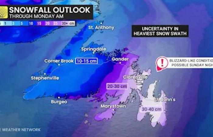
Two systems combining south of Nova Scotia will set the stage for heavy snow and possible blizzard-like conditions throughout southeastern Newfoundland starting Sunday night and lasting into Monday morning.

Newfoundland snowfall through Monday
While the track of the storm and location of greatest impacts remain uncertain, the storm looks to bring a swath of 20+ cm of accumulation to parts of Newfoundland.
Advertisement
Advertisement
Advertisement
Advertisement
High winds will accompany the low as it rapidly intensifies during its passage through the region. Gusts could approach 100 km/h if the storm tracks close to the Avalon Peninsula.
Drivers are urged to make alternate travel plans and avoid going out during the height of the storm. Scattered power outages are possible as a result of the high winds.
Stay with The Weather Network for the latest on conditions across Newfoundland.
WATCH: When does a snowstorm become a blizzard?
Click here to view the video
تم ادراج الخبر والعهده على المصدر، الرجاء الكتابة الينا لاي توضبح - برجاء اخبارنا بريديا عن خروقات لحقوق النشر للغير


