

اخبار العرب-كندا 24: الخميس 1 يناير 2026 08:32 صباحاً
Southern Ontario will enter the new year under the brunt of a stubborn Arctic air mass, allowing a multi-day, lake-effect snow event to continue--keeping drivers on edge and snowbelts busy to start the weekend, at least.
Some snowbelt communities have wracked up more than 30 cm of snowfall so far this week, with an additional 20-50 cm possible for some locales into Saturday morning. Snow squall warnings remain in place.
DON'T MISS: Feeling burned out? Try these tips to manage your holiday stress
A powerful storm has left behind bitterly cold air that has lasted for numerous days. Daytime highs will stay below freezing, with wind chills expected to feel closer to the -20s at times.

Southern Ontario forecast snowfall through Saturday - Jan. 1, 2026
New Year's Day snow and chill as bands shift
Snow depth reports as of Wednesday morning
-
Owen Sound: 47 cm
-
Northwest of Barrie: 36 cm
-
South of Kincardine: 30 cm
-
Durham: 23 cm
-
Woodstock: 18 cm
-
King City: 16 cm
-
Southwest of Ottawa: 14 cm
CHECK OUT: Is warming up your car in winter a smart move?
Below-freezing daytime highs and notable wind chills into 2026 will fuel lake-effect snow squalls.
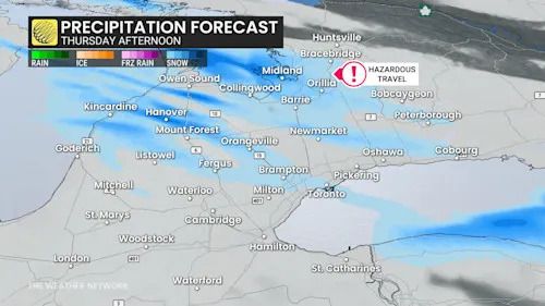
Southern Ontario Thursday evening forecast lake effect snow squalls - Jan. 1, 2026
Highly variable snowfall totals and driving conditions will depend on the location of the bands, which will be on the move.
Advertisement
Advertisement
Advertisement
Advertisement
Snow will be light and fluffy in the very-cold air temperatures, so blowing snow is a continued concern.
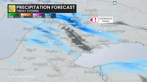
Conditions will continue through Friday, spilling into the weekend, with an additional 20-50 cm possible in the snowbelts and areas north of Barrie.
Southern Ontario Friday evening forecast lake effect snow squalls - Jan. 1, 2026
A particularly dangerous squall is forecast to lock into place late Thursday into Friday for the Collingwood, Barrie, Midland and Orillia areas, dumping, locally, up to 50 cm of snowfall in the hardest-hit locations.
Continued road closures are likely. Road closures are also possible for Highway 400 and Highway 11.
WATCH: Has it been the snowiest December on record for Toronto?
Click here to view the video
Ontario will ring in 2026 with widespread wind chills in the -20s across southern sections, and -30s across northeastern areas through early New Year’s Day.
Advertisement
Advertisement
Advertisement
Advertisement
Temperatures will dip close to -25ºC in Ottawa early Friday morning. Meanwhile, Timmins approaches temperatures near -30°C for overnight lows.
Public safety alerts issued amid hazardous travel
Extremely dangerous conditions have prompted official warnings in parts of central Ontario. The Township of Springwater declared a significant weather event, urging residents and motorists to stay off the roads.
Emergency Management Ontario has also issued a public safety alert for the area, warning that emergency services may be unable to respond, advising that all non-essential travel be avoided.
WATCH: OPP officer describes chaos as whiteouts shut down roads
Click here to view the video
Stay with The Weather Network for the latest updates across Ontario.
تم ادراج الخبر والعهده على المصدر، الرجاء الكتابة الينا لاي توضبح - برجاء اخبارنا بريديا عن خروقات لحقوق النشر للغير