


اخبار العرب-كندا 24: الأربعاء 17 ديسمبر 2025 11:08 صباحاً
A strong clipper will hit much of northern Ontario Wednesday and Thursday, bringing heavy snow and hazardous winter travel.
Snowfall totals of 15-30+ cm are forecast, accompanied by strong winds causing blowing snow and near-zero visibility. Road closures are possible. A flash freeze is also expected as temperatures drop rapidly into the minus teens and even -20s.
Expect potential disruptions to transportation, services, and utilities.
DON'T MISS: Simple steps you can take to prepare for a winter storm
Stay alert to the changing and deteriorating conditions, and monitor the latest weather warnings in your area.

Baron - Northern Ontario snow through Friday - Dec 17
Heavy snow and dangerous winter travel Wednesday and Thursday
A clipper system will bring widespread snow to northwestern Ontario from Wednesday afternoon into Thursday, resulting in hazardous travel conditions.
Advertisement
Advertisement
Advertisement
Advertisement
By Wednesday evening, snow will move into northwestern Ontario, with heavy snow starting in the Kenora and Dryden area. Overnight into Thursday, snowfall intensifies from Thunder Bay to Kapuskasing, with rates of 2 cm per hour expected.
Baron - Snow and winds northern Ontario - Dec 17
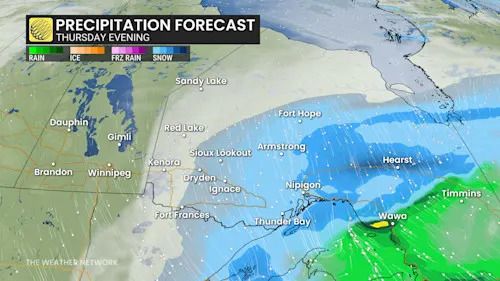
By Thursday morning, moisture from the Gulf of Mexico enhances snowfall in northeastern Ontario, increasing totals there.
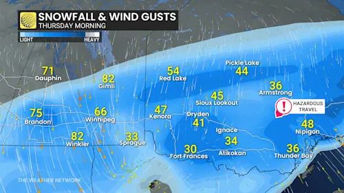
Thunder Bay will continue to see heavy snow and strong winds, with gusts of 40-70 km/h causing blowing snow and poor visibility on the back end of the system.
Baron - Northern Ontario precipitation Thursday evening - Dec 17
Snow continues into Friday for northeastern Ontario, while northwestern Ontario sees light flurries.
Advertisement
Advertisement
Advertisement
Advertisement
Highway 11 and 17 closures are likely between Nipigon, Kapuskasing, and Marathon.
Areas east of Lake Superior including the Nickel Belt will see some rain and mild temperatures ahead of the cold front, but the rain will change to snow before ending with a flash freeze likely as temperatures quickly plunge into the minus teens and even minus 20°C.
More widespread snow expected through the weekend
Another strong clipper system is set to move through the region Friday night into Saturday, bringing widespread snowfall, particularly to areas within the Nickel Belt and Sault Ste. Marie.
DON'T MISS: You asked for a white Christmas, and you may just get it!
The system will maintain changeable temperatures and an active weather pattern, which is expected to persist through Christmas and beyond.
WATCH: Why it could be a 'December to remember' for Ontario's snowbelt
Click here to view the video
تم ادراج الخبر والعهده على المصدر، الرجاء الكتابة الينا لاي توضبح - برجاء اخبارنا بريديا عن خروقات لحقوق النشر للغير