


اخبار العرب-كندا 24: الثلاثاء 16 ديسمبر 2025 08:56 صباحاً
A powerful storm will sweep across the Prairies Wednesday and Thursday, bringing blizzard conditions, potential road closures, and flash freezes in some areas. Strong winds also pose a risk of power outages.
DON'T MISS: What turns a snowstorm into a raging blizzard?
The system will redevelop east of the Rockies early Wednesday, with widespread snow forming near the Yellowhead Highway and spreading southeast into south-central Saskatchewan and Manitoba. Central Alberta could see 10-20 cm of snow, while 15-25 cm is expected for south-central Saskatchewan and Manitoba, impacting cities like Regina, Brandon, and Winnipeg.

Baron - Prairie snow - Dec 16
Blizzard conditions are likely, with whiteouts and dangerously cold wind chills creating hazardous conditions. Plan ahead as travel disruptions are anticipated.
Heavy snow and winds pick up across the Prairies Wednesday, dangerous blizzard conditions likely
A strong Alberta clipper will quickly track across the Prairies on Wednesday, affecting all three provinces with snow, wind, and potential blizzard conditions.
Advertisement
Advertisement
Advertisement
Advertisement
The system is expected to bring 15–30 cm of snow, particularly along major routes like the Yellowhead Highway and Trans-Canada Highway.
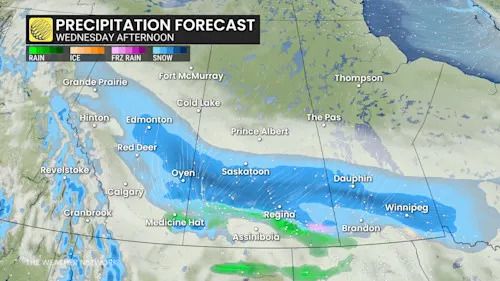
Baron - Prairies precipitation Wednesday afternoon - Dec 16
Snow begins in central Alberta, including Edmonton, early Wednesday, tapering off by evening. Winds gusting 40–60 km/h will reduce visibility and create slick roads, impacting the morning commute.
Snow spreads into southern Saskatchewan by late morning, intensifying into the afternoon with snowfall rates of 2–3 cm/h. Gusts of 40–60 km/h will cause blowing snow, with heavier impacts along major highways by evening. Southern Saskatchewan may initially face freezing rain along the Trans-Canada Highway, creating hazardous road conditions, as well.
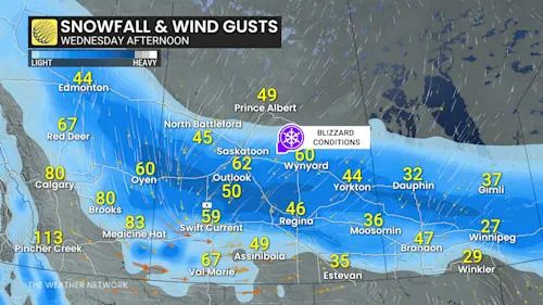
Baron - Prairie winds and snow - Dec 16
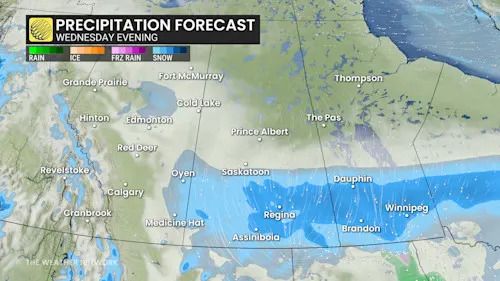
Southern Manitoba will see snow by Wednesday afternoon, becoming heavy by evening. Though snow tapers by Thursday morning, wind gusts up to 70 km/h will persist, resulting in blowing snow and difficult travel during the morning commute.
Advertisement
Advertisement
Advertisement
Advertisement
Winds of 110+ km/h could impact southern Alberta, Saskatchewan, and Manitoba from Wednesday afternoon into the night.
Baron - Prairies precipitation Wednesday evening - Dec 16
Winter storm watches and snowfall warnings are in effect. Travel could become dangerous, with blizzard-like conditions likely in southern Saskatchewan and Manitoba from Wednesday evening to early Thursday.
SEE ALSO: ECCC launches new colour-coded Canadian weather alerts
Wild temperature rollercoaster continues, brace for a flash freeze
Southern parts of the Prairies will experience dramatic temperature swings this week. On Wednesday, temperatures will rise well above freezing, with some areas reaching double digits, while regions north of the Arctic boundary will stay in the minus teens and 20s. A flash freeze is expected Wednesday night as Arctic air pushes south again.
DON’T MISS: La Niña to continue into 2026, leaving thumbprint on winter weather
Another brief warm-up is forecast for late Thursday, followed by a return to colder conditions. Areas near the U.S. border will continue to see highly variable temperatures into next week.
WATCH: Extreme winds flip tractor-trailers and ignite wildfire in Alberta
Click here to view the video
Stay with The Weather Network for the latest on conditions across the Prairies.
تم ادراج الخبر والعهده على المصدر، الرجاء الكتابة الينا لاي توضبح - برجاء اخبارنا بريديا عن خروقات لحقوق النشر للغير