


اخبار العرب-كندا 24: الاثنين 15 ديسمبر 2025 12:08 مساءً
You asked for a white Christmas, Ontario, and boy, are you going to get it.
Maybe.
Well, some regions in southern Ontario will probably get it thanks to the Great Lakes.
Snow squalls, while not unique to Ontario, play a major role in making winter that much more annoying and, unfortunately, that much more deadly. Squalls have been responsible for multiple major car pileups on the 402 and 400 highways, as the sudden, heavy snow and accompanying whiteout conditions can lead to zero visibility for drivers.
Advertisement
Advertisement
Advertisement
Advertisement
However, while we can see them coming, they’re not always easy to nail where they’re going to have their biggest impact.

Historical odds of a white Christmas Canada
Historical odds of a white Christmas. (The Weather Network)
RELATED: Why snow squalls are so tough to forecast
In the fall, I talked to our The Weather Network meteorologists about the effect the warm lake waters would have on our snow squall season, and my colleague and fellow meteorologist Dr. Doug Gillham told me that the temperature of the water in the early fall doesn’t have much of an effect on the snow squall season other than delaying ice formation until later in the winter.
Advertisement
Advertisement
Advertisement
Advertisement
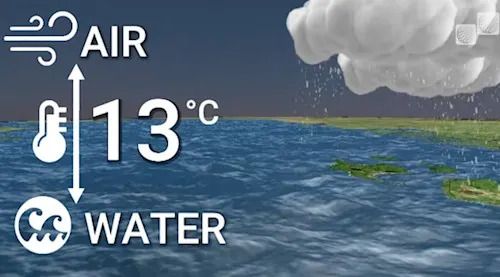
Ice is critical to squall formation because, to get a squall you need a 13-degree Celsius difference between the water temperature and the atmospheric temperature about a kilometre and half up. To get that, you need open water, not ice. This means that the prime squall season is in the late fall and early winter.
EXPLAINER: Snow squall development off Great Lakes - to get a squall you need a 13-degree Celsius difference between the water temperature and the atmospheric temperature about a kilometre and half up. To get that, you need open water, not ice
Snow squall recipe. (The Weather Network)
DON'T MISS: Many Canadians dream of a white Christmas, but what are the odds of it?
So, given the timing and what seemed to be an earlier than usual snow season, I went back to Dr Doug in early December for an update.
"If we were expecting a mild December, we wouldn’t be anticipating much lake effect snow because those shots of cold air behind low pressure systems wouldn’t be there," he explained. "The key is that if we have a stagnant, even cold air mass over the Lakes for all December, we wouldn’t see much lake effect snow because the air isn’t moving. If we have frequent storms that create more shots of cold air, you’re reinforcing that cold regime and each time a cold front goes through, we’ll get a fresh round of lake effect snow."
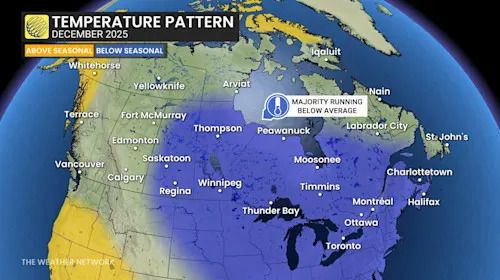
December 2025 Temperature Pattern
Temperature pattern forecast for December. (The Weather Network)
Advertisement
Advertisement
Advertisement
Advertisement
Weather is the same as real estate; it’s all about location and Doug emphasized this, “Some places are going to see really impressive amounts and that includes ski country. Ski hills should be in great shape as we head into the holiday season. So, if you’re after downhill, cross country or even snowmobiling, there should be an abundance of snow on the ground in the traditional snowbelt areas.”
Having been through snow squalls many times as a storm chaser, I’m very aware of their variability. I’ve been in some that are so bad that you can just barely see the end of the hood of the car to ones that leave just a dusting on the grass.
Doug stresses that the difference between a devastating event and one that can be moved by a broom and a slight effort comes down to wind direction and persistence, “The key to a nuisance streamer and one that paralyzes a region for days is whether the winds come persistently from the same direction. It’s not so much the snowfall rate; that’s pretty consistent. It’s all about whether the bands lock into place for 24, 48 or 72 hours or they pivot through a region. More often they pivot, but sometimes they lock into place and that’s when we see the high impact events.”
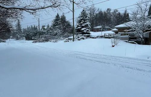
Orillia, Ont. snow/Nathan Howes/TWN
Ontario's snowbelt regions are more than likely to see a 'white Christmas' given the current snow on the ground and temperatures remaining on the cool side. (Photo taken in Orillia, Ont. Courtesy of Nathan Howes/The Weather Network)
Advertisement
Advertisement
Advertisement
Advertisement
As with all things though, the squall season will come to an end, driven by the very cold that creates the snow. “An extended period of cold weather means that eventually the lakes will ice over. That’s deeper into the winter; really the colder air in December has a bigger effect on the second half of winter – January and February. We’re not going to freeze up the lakes over December because it takes a long time to remove enough heat from the water to start getting ice buildup. Lake Erie is usually the first to freeze, but the other lakes, including Georgian Bay will be open right through to January.”
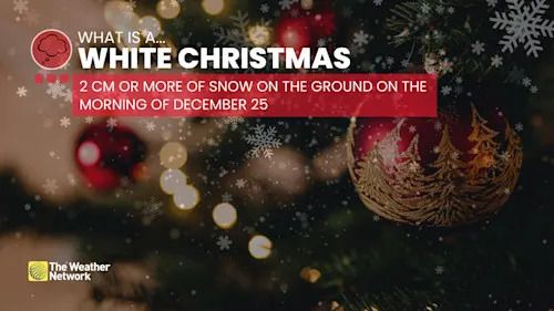
White Christmas definition/explainer
Definition of a 'white Christmas' (The Weather Network)
For me, the bottom line is that I’m seriously looking into finally getting a snowblower. Living in Guelph, this area isn’t directly under the usual snow squall path, but when it is, we can get some impressive amounts. Given the probability of multiple events this winter though, the chances that I’m going to get buried are potentially better than me getting hit by lightning.
And yes, I’m ready for spring to come any time now.
Please?
RELATED VIDEO: Will intense lake-effect snow result from warmer Great Lakes?
Click here to view the video
(Thumbnail: File photo courtesy of Johnyboy Entertainment Center Sonier. Submitted to The Weather Network)
تم ادراج الخبر والعهده على المصدر، الرجاء الكتابة الينا لاي توضبح - برجاء اخبارنا بريديا عن خروقات لحقوق النشر للغير