


اخبار العرب-كندا 24: الخميس 13 يونيو 2024 12:34 مساءً
Conditions are favourable for the formation of severe thunderstorms, which could produce tornadoes across parts of southern Ontario and Quebec today. A tornado watch has been issued. Damaging winds, large hail, and torrential rains are also possible.
Current tornado watches:
Ontario:
ALGONQUIN
BANCROFT - BON ECHO PARK
BARRIE - ORILLIA - MIDLAND
BURK'S FALLS - BAYFIELD INLET
DUFFERIN - INNISFIL
HALIBURTON
HALTON - PEEL
PARRY SOUND - MUSKOKA
PETERBOROUGH - KAWARTHA LAKES
RENFREW - PEMBROKE - BARRY'S BAY
YORK - DURHAM

Quebec:
MONT-LAURIER
LA VERENDRYE WILDLIFE RESERVE
UPPER GATINEAU - LIEVRE - PAPINEAU
PONTIAC
ABITIBI
TEMISCAMINGUE
PARENT - GOUIN RESERVOIR.

9:54 AM EDT
Conditions are favourable for the development of severe thunderstorms which may produce tornadoes. Strong winds, large hail and heavy rain are also possible.
The potential for tornadoes will exist afternoon and early this evening.
In the event of a tornado, or if a tornado warning is issued for your area, it is recommended you take the following actions: Go indoors to a room on the lowest floor, away from outside walls and windows, such as a basement, bathroom, stairwell or interior closet.
Leave mobile homes, vehicles, tents, trailers and other temporary or free-standing shelter, and move to a strong building if you can. As a last resort, lie in a low spot and protect your head from flying debris. Lightning kills and injures Canadians every year. Remember, when thunder roars, go indoors!
Tornado watches are issued when atmospheric conditions are favourable for the development of thunderstorms that could produce tornadoes.
__Read the rest of the article down below: __
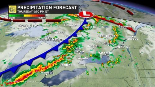
Muggy air building back in across parts of Ontario and Quebec will bring the threat for severe weather to crop up across both provinces on Thursday.
With the increasing heat and high humidity, comes instability in the atmosphere. A cold front moving through Ontario on Thursday will trigger a risk for thunderstorms, with the likelihood for some to become severe.
In fact, Thursday has the potential to be the most severe weather day of the season so far for southern Ontario and western Quebec, so it will be important to stay on top of the weather watches and warnings in your area, as conditions can change quickly when severe weather hits.

DON'T MISS: What to do if a tornado warning is issued
Thursday: Severe weather to bubble up across the province
A strong cold front pushing eastward through the lower Great Lakes region this week will clash with the warm, humid air in place, triggering widespread rain and embedded thunderstorms in its path.
Nothern Ontario was the first area of the province to see the active weather as storms rolled through the region Wednesday night. The real risk comes to southern and eastern Ontario, and western Quebec later Thursday.
SEE ALSO: The Great Lakes may have a thunderous effect on your summer weather
Temperatures in the mid- to high-20s will feel like the mid-30s with the humidity on Thursday. Folks in Toronto will be seeing an already scorching daytime high in the upper 20s, but the humidex will make it feel well into the 30s. This will create enough energy in the atmosphere for strong storms to develop upon the cold front's arrival later in the day.

There is the potential for a few showers or thunderstorms on Thursday morning, but there should be sufficient clearing in the afternoon to recharge the atmosphere ahead of the passage of the cold front. Most of southern Ontario should stay rain free the majority of the day
While there is still some uncertainty on the exact timing of the passage of the storms, by the late afternoon, and as the cold front nears, the more intense thunderstorms are likely to continue through the evening hours and potentially through the overnight hours as well.

Torrential rain, strong wind gusts, large hail, and even a tornado or two are strong possibilities for Thursday. Be sure to be weather-aware as damage is possible given the severity of this system.
With the likelihood of severe storms throughout the province, it is important to have a plan in place. Secure loose objects outdoors like patio furniture, ensure phones and electronics are charged, and plan for quick access to head indoors or to lower levels.
The dreary, stormy weather will stick around through the overnight Thursday, giving Friday a less-than-ideal start. Things will turn around in a hurry however, with the region finally looking to pull off a dry weekend -- the first in the GTA since early April!
Saturday will be a gorgeous day with abundant sunshine, light wind and comfortable temperatures during the afternoon. A mix of sun and clouds is expected for Sunday.
MUST SEE: Will the streak finally end with a dry Father's Day weekend?
By next week, conditions will become hot and very humid for most of the week, with high temperatures soaring into the low to mid 30s for a few days, and a 40+ humidex. However, with the very muggy conditions will come a risk for thunderstorms, once again.
Warmer than normal temperatures are expected to dominate through the end of the month, but quick shots of cooler weather near seasonal, are also are possible.
Stay with The Weather Network for more forecast information and updates on your weather across Ontario and Quebec.
WATCH: Severe weather risk stretches across Ontario's cottage country
Click here to view the video
تم ادراج الخبر والعهده على المصدر، الرجاء الكتابة الينا لاي توضبح - برجاء اخبارنا بريديا عن خروقات لحقوق النشر للغير

