


اخبار العرب-كندا 24: الخميس 1 فبراير 2024 09:01 صباحاً
Click here to view the video
Welcome to February, and the beginning of a pretty active pattern across Atlantic Canada. Despite the teases with early spring here and there, we are just starting the month of February, a simple indication that we aren't done with the season just yet.
MUST SEE: El Niño and the polar vortex take centre stage for winter’s final chapter
In fact, winter is expected to re-emerge this month, and the focus of its fury should be across Eastern Canada.
Snow and gusty winds are forecast over the region for the next couple of days, with some of the hardest hit areas picking up 20+ cm into Friday. That's ahead of another snowy system developing offshore through the weekend. Be prepared to adjust to the changing conditions, and plan ahead for difficult travel in the snow.
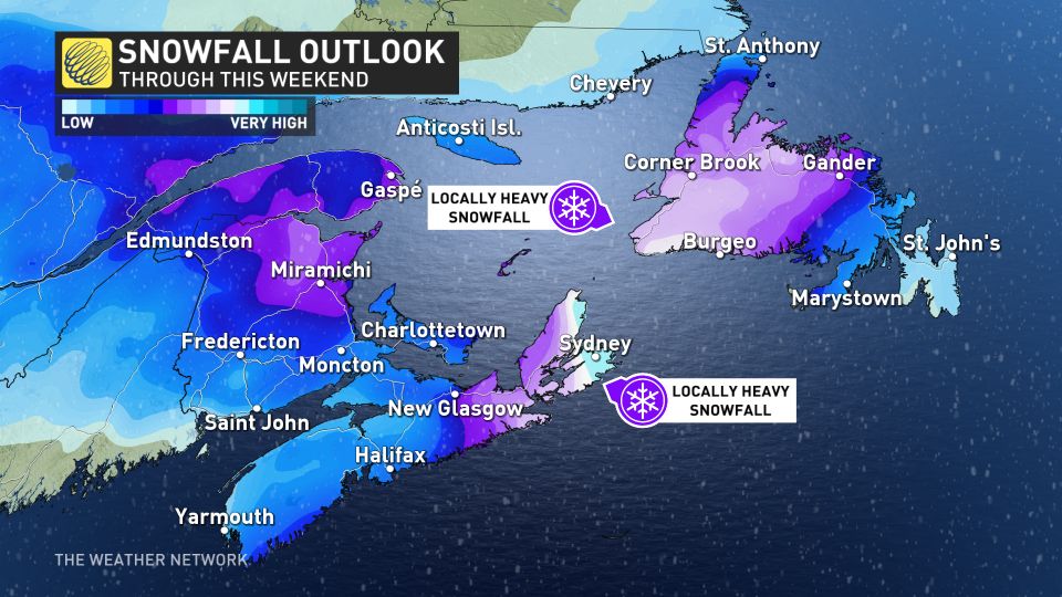
Thursday into Friday
Snowfall began in northern New Brunswick early Thursday morning, and will spread south of the province throughout the day.
Significant snow may accumulate in sections of the northeast, where 15-20+ cm is likely, persisting into Friday.

Snow will build into Nova Scotia on Friday as well, with the chance of mixing along the south coast. Between 5-10 cm is expected across eastern Nova Scotia, and P.E.I.
This same instability will pull in another snowy system developing offshore through the weekend.
This weekend
A second low will develop south of Nova Scotia and meander south of Newfoundland this weekend.
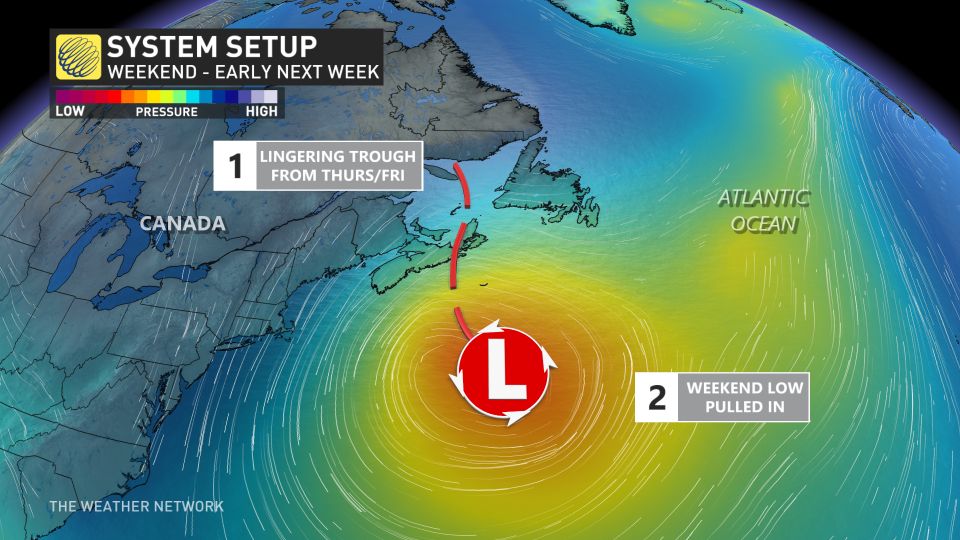
Consistent snowfall is forecast through the weekend and into early next week. The snow will also be accompanied with gusty winds in the 50-70 km/h range, which could make for poor travel and reduced visibility at times.
Still being several days out, and with several factors at play, the exact track and local impacts are uncertain. But you can expect an extended period of unsettled weather, including substantial snow totals for much of Newfoundland and the eastern Maritimes.
Above seasonal temperatures are expected to dominate during the first half of February, with a few days of fair weather likely during the middle of next week. We're closely watching the track of a large storm, which is expected to track well south of the region late next week.
Be sure to check back for the latest weather updates across Atlantic Canada.
تم ادراج الخبر والعهده على المصدر، الرجاء الكتابة الينا لاي توضبح - برجاء اخبارنا بريديا عن خروقات لحقوق النشر للغير


